Wintering in Texas: part 2
Feb. 2022

At the beginning of February, we started traveling again. First, we headed to Big Bend Natl. Park. We didn’t realize how large this park is, until we started driving around it over a 3-day period. It’s the 14th largest U.S. National Park (7th largest in the lower 48).

On the first day, we drove from Terlingua, where we were camped, down the Ross Maxwell Scenic Drive, to Santa Elena Canyon. As you look up at the canyon from the river’s edge, the cliffs on the right are on the U.S. side, and the cliffs on the left are in Mexico

The canyon is 8 miles long, and the cliffs are 1500 feet high. In some places, the bottom of the canyon is only 30 feet wide. We saw some people walking on a trail above the river along the cliff on the right, but they had to walk through water in order to get to the trail. We didn’t want to get our shoes wet, so we didn’t go on the trail.
That same day, we walked down the Tuff Canyon trail. It was right off the scenic drive, and it went down into a small canyon.

View of Tuff Canyon from the overlook


Also along the scenic drive was an overlook for Mule Ears. We did not hike the trail, though.
The next day, we traveled up the pretty drive to the Chisos Basin section of the park, in the Chisos Mountains. We pulled off at several places along the drive to look at the mountains, and at one stop, we chatted for quite awhile with a very nice couple who had spent years full-time traveling. We meet such nice, interesting people along the way!

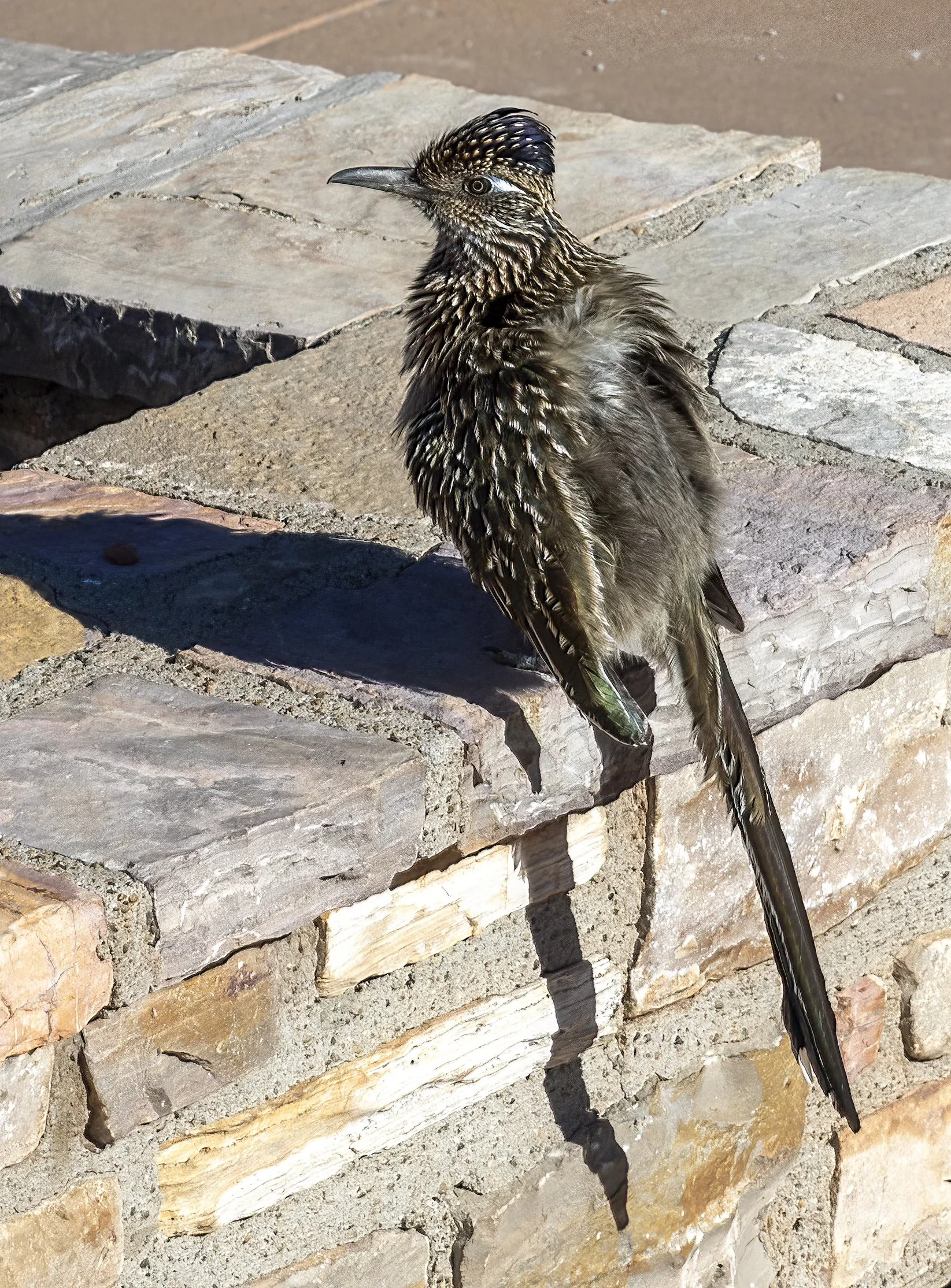
When we got to the visitor center, we saw this roadrunner up close, right on the sidewalk! First time we’d seen one! It just posed for us!

From here, we walked the short, paved trail to the Window View. We did not hike the 5-mile round-trip trail down close to the Window, because it was long and would be uphill coming back. We did hike the Basin Loop trail, though.


That afternoon, we drove several miles down a dirt road (the last half-mile or so was a little rough!) to get to the trail to Balanced Rock. Most of the trail is flat, except for the last quarter-mile, which is a rock scramble up a hill. That part was not easy!


View of the flat part of the trail to Balanced Rock, from partway up the hill


The next day, we drove in the opposite direction from Terlingua to Big Bend Ranch State Park. This is a huge park, but the only paved road is the scenic drive which parallels the Rio Grande. We hiked the Closed Canyon trail. It is a slot canyon with high rock walls.


Then we drove farther west to the Hoodoos. Here there was a short trail to an overlook where we could see a few small rock formations, the Rio Grande, and Mexico on the other side of the river. The trail branched off so people could walk closer to the hoodoos.

There were just a few hoodoos, but it was quite a scenic view from the top of the hill.
On our last day, we drove to the east side of Big Bend. The first thing we did was walk the nature trail near the Rio Grande Village campground, which started on a boardwalk through a wetland area, and then ascended a hill from which we could see the Rio Grande and Mexico.

Mexico is on the left side of the river, and the campground is on the right.
Then, at Boquillas Crossing, we paid a Mexican guide $5/pp to cross the shallow Rio Grande in a rowboat and we entered Mexico! Boquillas is a small, dusty town that relies on tourist dollars. We had lunch at one of the two restaurants, and bought some Mexican vanilla.

Craig’s first visit to Mexico! It wasn’t anything special, but a check off the bucket list!
In order to cross back into the U.S., we had to show our passport at the Port of Entry. After that, we hiked the nearby Boquillas Canyon trail. This trail wound down to the Rio Grande and ended at the canyon walls at a very pretty spot.

The Rio Grande is shallow and narrow at this point. The canyon walls on the right are in Mexico. So close! In fact, on this trail, we saw a few Mexican nationals that had crossed the river either on foot or on horseback. One was hoping we would give money or a granola bar in exchange for a serenade, and the others were selling food.
We enjoyed Big Bend much more than we thought we would, as there was a lot to see, and it wasn’t just desert. It wasn’t crowded, either.
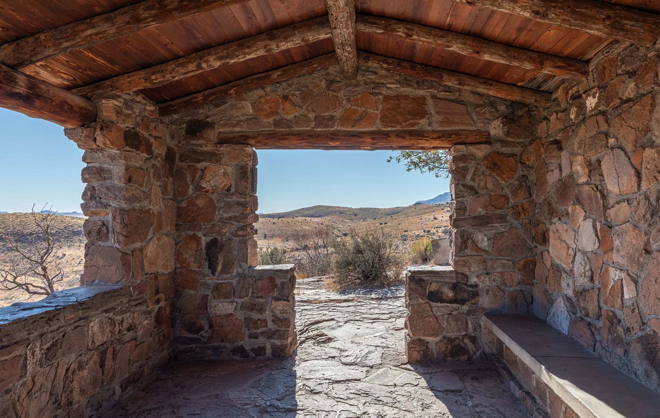
However, it was time to move on. Our next stop was a stay in Davis Mountains State Park in the west Texas town of Fort Davis. We really liked this area, although it was a little chilly in February. The park was pretty, and had great views of the surrounding area. We would actually like to come back someday and stay in the beautiful lodge that was built by the CCC in the 1930’s.


We drove up the scenic drive in the park, where there was an expansive view. The CCC built a rock shelter at the top of the mountain.

The CCC also disguised the water tank by covering it in a “castle” of rock.

While we were in the area, we visited the McDonald Observatory, a research facility owned by the University of Texas. The two largest telescopes, which we could see from miles away, are on neighboring mountains well over 6000 ft. high.

At the time this telescope was built in the 1930’s, it was the second-largest in the world. It is still in use. It sits on the highest public road in Texas at an elevation of almost 6800 ft. Visitors are not allowed inside this building.

Visitors are allowed inside this building. We could look through a window at the inside of the dome.

The next day, we visited Fort Davis National Historic Site. Before the Civil War, Fort Davis was built to provide protection from Comanches and Apaches to pioneers traveling from San Antonio to El Paso. After being unoccupied during most of the Civil War, it was rebuilt, and these ruins are what we see today.

Officer’s quarters


Officers’ Row
Officers’ Row faces a large parade ground and the enlisted men’s barracks on the other side. The fort was large, and gave a good impression of what life was like in the West in the 1870’s and 1880’s.
On our way from Fort Davis to Hueco Tanks State Park near El Paso, we stopped at Prada Marfa, an art installation in the middle of nowhere.

This sits on a 2-lane highway next to an empty field. There’s a wide spot to park across the road. Fun quick diversion!

Actual merchandise from Prada’s 2005 collection
Our last stop in Texas was Hueco Tanks State Park. We had a fantastic campsite backing up to the rocky hillside, including a covered picnic area. The tanks are natural rock basins that have provided water in this arid environment for people and animals for thousands of years. There are ancient pictographs all over this area, many of which have been covered by graffiti over the last hundred and fifty years. In order to visit this area, we had to watch a short video about the park, and reserve a permit for a self-guided tour of North Mountain. We also reserved a guided tour, which would take us to part of South Mountain. A lot of people like to go rock-climbing in this area, but climbing is allowed only with a guide. All these restrictions are in place to prevent additional damage to the pictographs.

The back of our campsite

One of the ponds in the North Mountain area


Craig climbed the chain trail up North Mountain.
This was the end of our winter stay in Texas. We had a great time!